Trusted company that deals in quality-made products
Mon - Sat 8:00 - 6:30

Welcome to

Rchobbytech Solutions Private Limited

Offering Surveillance Drones, Agricultural Drones, Drone Pilot Training, Drone Lab Setup, Integration Services, and Turnkey Drone Solutions.

Rchobbytech Solutions Private Limited is a leading drone technology company headquartered in Eastern India, delivering integrated solutions across agriculture, defence, and enterprise domains. We design, manufacture, and deploy unmanned aerial systems tailored for applications such as surveillance, aerial mapping, precision spraying, and crop monitoring.

Our in-house capabilities include advanced R&D, full-scale production units, and DGCA-certified remote pilot training facilities. By combining high-performance UAV platforms with intelligent software and operational expertise, we enable government bodies, institutions, and private enterprises to achieve data-driven, mission-ready outcomes with efficiency and accuracy.
KEY FACTS OF COMPANY
Our Category
Banner Banner Banner Banner Banner Banner Banner Banner
Most Popular Product
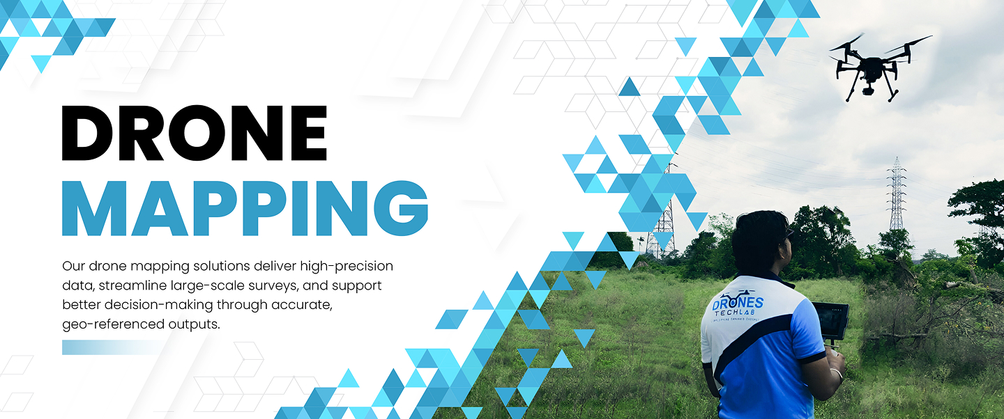
2 KG VTOL Fixed Wing UAV
Our VTOL Fixed Wing UAV merges vertical take-off and landing versatility with the endurance and efficiency of fixed-wing flight. With up to 90 minutes of flight time, 2 kg payload capacity, and advanced navigation systems, it is a dependable solution for surveillance, mapping, light logistics, and emergency operations in diverse environments.
Surveillance & 10kg Payload Dropping Drone
Our Surveillance & Payload Dropping Drone is designed for dual-role operations, combining high-capacity payload deployment with advanced aerial surveillance. With a 10 kg payload limit, up to 120 minutes of flight endurance, and a stabilized hybrid zoom gimbal camera, it delivers dependable performance for border security, long-range deliveries, infrastructure inspections, emergency response, and operations in high-altitude environments.
FPV Drone
Purpose-built for real-time situational awareness, the FPV Drone combines low-latency HD video transmission with precise flight control, ideal for tactical surveillance, inspection, and operational training. Its compact, agile design and immersive first-person view allow professionals to navigate confined or complex environments with exceptional accuracy and speed.

Clientele

At RC Hobbytech Solutions Pvt. Ltd., we take pride in being a trusted UAV technology partner to some of the nations most respected institutions. Our solutions are deployed across sectors including defence, aerospace, infrastructure, governance, and researchpowering critical missions with precision and impact.

We are honoured to serve:

Defence & Homeland Security

Indian Army Indian Air Force DRDO National Defence Academy (NDA) Assam Police West Bengal Police

Aerospace & Strategic Enterprises

Hindustan Aeronautics Limited (HAL) Bharat Electronics Limited (BEL) Steel Authority of India Limited (SAIL) IRCON International Ltd.

Government Bodies & Urban Development

Guwahati Metropolitan Development Authority (GMDA) Assam Forest Department Kolkata Municipal Corporation Archaeological Survey of India

Research & Scientific Institutions

Borlaug Institute for South Asia (BISA) CSIRCentral Electronics Engineering Research Institute (CEERI)

Technology & Industrial Leaders

JSW Group Larsen & Toubro (L&T) Central Design Centre (CDC Kolkata)

Digital & Administrative Systems

National Informatics Centre (NIC) Integrated Basin Development & Livelihood Promotion Programme (IBDLP), Meghalaya

Disaster Management & Resilience

National Disaster Management Authority (NDMA) Regional Disaster Response and Management Authorities

Each collaboration reflects our commitment to advancing Indias drone ecosystem through innovation, reliability, and mission-aligned solutions.
Hot Products
Drone Lab Setup
Drones Tech Lab brings to you the Drone Lab Setup, an all-inclusive solution for revolutionizing education and research in drone technology. Designed for institutions, researchers, and enthusiasts, our Drone Lab Setup offers everything required to explore, innovate, and master the art of drone technology.
Drone Pilot Training Course
Our Drone Pilot Training courses include the Micro Category Drone Pilot Training Course, ideal for beginners and those looking to operate smaller drones between 250gm to 2 KG for personal or recreational use. We also offer the Small Category Drone Pilot Training Course, which is suitable for individuals interested in flying drones between 2 KG to 25 KG for commercial purposes in a controlled environment. For those aspiring to operate larger drones for commercial applications, our Medium Category Drone Pilot Training Course provides the necessary skills and knowledge to fly drones between 25 KG to 150 KG. Join us at Drones Tech Lab and embark on an exciting journey into the world of drone piloting!
LiDAR Based City Mapping
LiDAR-based city mapping using drones uses laser pulses to measure distances to objects, allowing for the creation of 3D models of buildings, streets, and other features. One of the key benefits of LiDAR-based city mapping is its ability to capture detailed information about the urban environment, including building heights, road widths, and vegetation cover. This data can be used by urban planners, architects, and engineers to design more efficient and sustainable cities. Overall, LiDAR-based city mapping using drones offers a powerful tool for creating detailed and accurate maps of urban areas, with a wide range of applications across different industries.

Contact us now

Enquiry Now

Please take a moment to complete this form and a business representative will get back to you swiftly.
Back to top