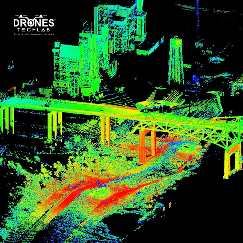
About LiDAR Based City Mapping
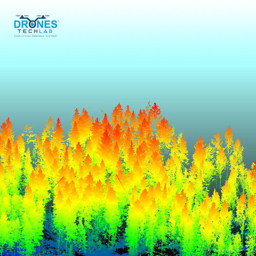
Find the latest in urban mapping solutions with our premier LiDAR Based City Mapping services. Designed for outdoor urban and city landscapes, our solution utilizes classic laser scanner technology paired with GNSS/IMU integrated positioning systems, achieving laureate-level accuracy: up to 10 cm vertically and 20 cm horizontally (model dependent). Effortlessly map areas exceeding 100 sq km per mission with rapid data acquisition and cloud processing capabilities. We offer support for LAS, LAZ, DEM, DSM, orthophoto, and RGB colorized point clouds, making this an ideal offering for urban planners and infrastructure development across India.
Comprehensive Application for Urban Excellence
LiDAR Based City Mapping stands as the premier choice for urban planners and municipalities. Ideal for city landscapes and infrastructure development, it seamlessly supports 3D terrain modeling and large-scale urban planning projects. This solution delivers results in varied formats like DEM, DSM, and orthophoto, with colorized point clouds for enhanced visualization. Compatible with cloud processing, its robust media application ensures rapid, detailed outputs-supporting classic and innovative approaches to city management.
Domestic Coverage and Premium Delivery Standards
Our main domestic market encompasses urban centers, municipalities, and infrastructure consultants across India. Goods are shipped from leading domestic FOB ports, ensuring prompt service and reliability. Typically, shipped goods reach clients within industry-standard delivery times, underlining our commitment to premium logistics. With a strong focus on quality and speed, our laureate service guarantees secure, on-time delivery, so clients experience effortless project launches and ongoing operational excellence every time.
FAQ's of LiDAR Based City Mapping:
Q: How does the LiDAR Based City Mapping system achieve its high accuracy in urban environments?
A: The system combines premier laser scanner technology with GNSS/IMU integrated positioning to achieve vertical accuracy up to 10 cm and horizontal accuracy up to 20 cm, depending on the model. This ensures precise and reliable mapping for city landscapes.
Q: What is the process for city mapping using this LiDAR solution?
A: The mapping mission involves rapid data acquisition with the onboard or external battery-powered LiDAR scanner, followed by advanced post-processing. Final deliverables are available in compatible formats such as LAS, LAZ, DEM, DSM, and orthophotos.
Q: Where can this LiDAR mapping service be effectively used?
A: Our service is ideal for outdoor urban and city landscapes, supporting applications like urban planning, infrastructure development, and 3D terrain modeling across various municipalities, smart city projects, and large infrastructure developments in India.
Q: When can clients expect the delivery of processed mapping data after a mission?
A: Processed data is delivered swiftly within agreed-upon project timelines. We prioritize rapid data acquisition and efficient post-processing, ensuring clients receive their results on schedule to support timely decision-making.
Q: What are the benefits of using this LiDAR Based City Mapping solution for urban development projects?
A: Clients benefit from high-area coverage, detailed and RGB colorized outputs, support for multiple contemporary data formats, and cloud processing capabilities-all enabling effective urban planning, infrastructure design, and 3D modeling.


 Send Inquiry

 Call Me Free
 English
 Spanish
 French
 German
 Italian
 Chinese (Simplified)
 Japanese
 Korean
 Arabic
 Portuguese