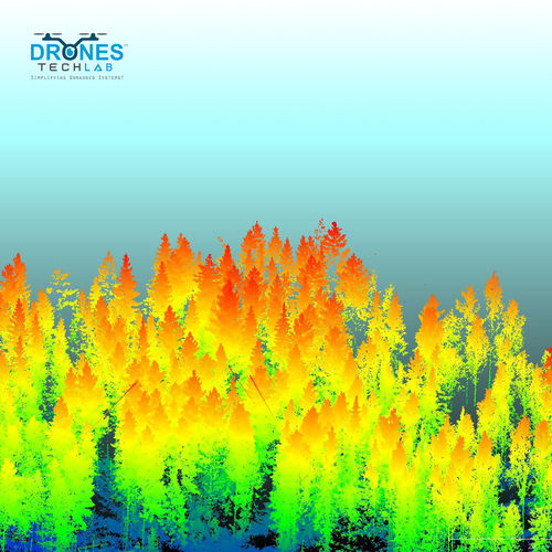
About LiDAR-based Forest Survey
LiDAR-based forest survey using drones helps to gather high-resolution data about forested areas. LiDAR sensors emit laser pulses that measure distances to objects on the ground, creating detailed 3D maps of the forest canopy and terrain. LiDAR technology using Drones offers several benefits for forest surveying. It provides highly accurate and detailed information about forest structure, including tree height, ground elevation, and others. This data is valuable for forest management, including planning logging operations, monitoring forest health, and assessing biodiversity. LiDAR-based forest surveys using drones are more efficient and cost-effective than traditional surveying methods, making them an increasingly popular tool for forestry professionals.
Comprehensive Forest Mapping SolutionLeverage the power of LiDAR technology for precise, high-resolution 3D forest mapping and vegetation analysis. This system integrates robust GNSS positioning and supports both UAV and ground vehicle platforms, allowing for flexible data capture in diverse terrains and conditions.
Seamless Data Handling & Extended OperationWith up to 1TB of onboard storage and support for common formats like LAS, LAZ, and GeoTIFF, managing and sharing your LiDAR data is streamlined. Operate continuously for up to 4 hours and benefit from automated and manual calibration for reliable data quality every session.
Advanced Processing & CompatibilityTake advantage of built-in cloud processing compatibility to accelerate your data analysis workflows. Whether you're conducting detailed vegetation analysis or mapping large forest expanses, transfer your data easily via WiFi or USB 3.0 for efficient collaboration and storage.
FAQ's of LiDAR-based Forest Survey:
Q: How does the LiDAR-based Forest Survey system operate in challenging forest environments?
A: The LiDAR-based Forest Survey system is built to perform in diverse and rugged forests. It utilizes high-resolution laser scanning and real-time GNSS positioning to capture accurate 3D point clouds, even under dense canopy or uneven terrain, and can function reliably from -10C to 50C.
Q: What platforms can this LiDAR system be deployed on for forest surveys?
A: This system is engineered to be lightweight and adaptable, making it suitable for mounting on UAVs/drones or ground vehicles. It supports both aerial and terrestrial scanning, offering flexibility based on project requirements and terrain accessibility.
Q: When is calibration required, and how is it performed?
A: Calibration can be performed both manually and automatically. Automated calibration ensures quick readiness for standard surveys, while manual calibration allows for fine-tuning in complex field conditions, enhancing the accuracy of the data.
Q: Where can the data collected be processed and analyzed?
A: The system supports cloud processing, allowing data to be uploaded for advanced analysis remotely. Alternatively, users can transfer files via USB 3.0 or WiFi to local workstations for customized processing using compatible software that reads LAS, LAZ, or GeoTIFF formats.
Q: What is the procedure for transferring collected data from the device?
A: Data can be transferred directly from the device's 1TB onboard memory using high-speed USB 3.0 or wirelessly via WiFi. These options provide flexibility for workflows in both field and office environments.
Q: How does using this LiDAR system benefit forest survey projects?
A: The system delivers rapid, high-resolution 3D data collection, significantly reducing time spent in the field and post-processing. Its accuracy, cloud compatibility, and robust design make it ideal for precise forest inventory, biomass estimation, and change detection analyses.


 Send Inquiry


 English
 Spanish
 French
 German
 Italian
 Chinese (Simplified)
 Japanese
 Korean
 Arabic
 Portuguese