About Topographic survey and mapping with drones
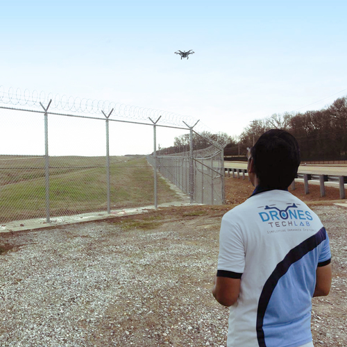
All you need is an updated technology which aims to change the entire working scenario of your organization. Drone technology has emerged as a common tool that aims to alter the scenario of topographic surveying. You get the detailed capture of the land, site maps, terrains, contour, and that too at much lesser time.
With the Government in favor of drafting easy regulation for certification, it is now at everyones reach. The drones not only become affordable, but a survey that takes an hour and sometimes days are completed within an hour. The datas is there within 24 hours. The drone-captured data gives you a quick, easier and safe way to showcase digitized terrain models as well as aerial site maps.
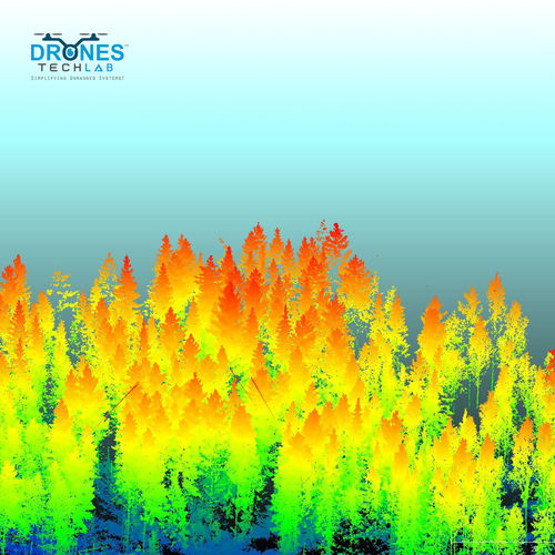
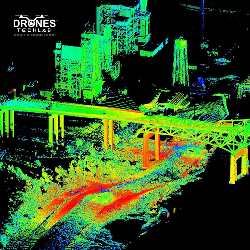
Advanced Drone Survey TechnologyOur topographic surveys leverage state-of-the-art UAVs equipped with high-resolution RGB and multispectral cameras, ensuring precise data collection for varied applications. RTK/PPK integration guarantees highly accurate georeferencing, delivering survey results with 1-5 cm accuracy, suitable for the most demanding projects.
Flexible Data Outputs and DeliveryReceive your survey results in a range of industry-standard formats-including DWG, DXF, SHP, LAS, and GeoTIFF-via secure digital delivery. Optional cloud-based storage simplifies project collaboration and data management, allowing stakeholders to access results quickly and efficiently.
Fast and Compliant OperationsWith a typical turnaround of 1-3 days depending on project scope, our surveys maximize operational efficiency while adhering strictly to DGCA/FAA regulations. Our skilled team ensures every project is compliant, secure, and optimized for high-quality output, even across large areas up to 10 sq. km per flight.
FAQ's of Topographic survey and mapping with drones:
Q: How is topographic surveying with drones different from traditional methods?
A: Drone-based topographic surveys utilize high-resolution cameras, RTK/PPK GNSS, and advanced processing software for rapid, accurate mapping of large areas. This reduces field time, increases safety, and provides digital outputs compatible with CAD and GIS systems, unlike labor-intensive manual surveys.
Q: What accuracy can be achieved in drone-based topographic surveys?
A: With advanced RTK/PPK-enabled drones, our surveys achieve 1-5 cm accuracy, especially when optional ground control points (GCPs) are used. High-resolution RGB sensors and precise GNSS integration greatly enhance data reliability for planning and engineering projects.
Q: When is the ideal time and weather for drone mapping operations?
A: Surveys are conducted during clear, dry, and non-windy conditions for optimal image quality and accuracy. Weather limitations ensure the drone's performance and data consistency, so surveying may be rescheduled in adverse weather.
Q: Where can your drone mapping services be utilized?
A: Our services are available across India and can be applied to various sectors, including land mapping, construction, agriculture, mining, and urban planning. Coverage per flight can reach up to 10 sq. km depending on drone specifications.
Q: What is the typical process from order to data delivery?
A: After project consultation, we plan the drone flight based on your site and data needs. We conduct UAV operations, process data using industry-grade software (e.g., Pix4D, DroneDeploy), and deliver results-such as orthomosaics and 3D models-digitally within 1-3 days, in your preferred formats.
Q: How are the survey results delivered and managed?
A: Results are delivered digitally in formats like DWG, DXF, SHP, LAS, and GeoTIFF. Clients also have the option for secure, cloud-based data storage and management, streamlining access and collaboration for project stakeholders.


 Send Inquiry

 English
 Spanish
 French
 German
 Italian
 Chinese (Simplified)
 Japanese
 Korean
 Arabic
 Portuguese